Section 2: The Development of the Timberlake Community Property
By John Rennie, 2009
The Timberlake community[i] includes 37 houses and 4 undeveloped lots on Timberlake Drive, four houses on Maloney Road and one house on Montlake Drive. Four houses on Timberlake Drive at the Montlake Drive are on land once owned by Roy S. Jones and his wife, Dorothy M. Jones. The land on the southwest side of Timberlake Drive at Montlake Drive was sold to Albert A. and Louise V. Woods [Warranty Deed (WD) Book 889, page 47, Knox County Registrar of Deeds] in April 1952. The Woods divided the tract into three lots. They build their house on the lot at 3301 Timberlake Drive, sold the second lot to Walter and Desta McGuire Shea [WD 946, p. 416] who built their house at 3313 Timberlake Drive and sold the third lot at 3306 Montlake Drive (not included in the Timberlake community). The land on the northeast side of Timberlake Drive at Montlake Drive was subdivided into two lots [Map Book 26, page 2] by the Jones. These lots were sold in November 1960 to Lewis H. and Sara W. Dickson [WD 1160, p. 515] and James H. and Mary Sue M. Robinson [WD 1160, p. 531]. The Dicksons build the house at 3304 Timberlake Drive and the Robinsons built the house at 3300 Timberlake Drive.
The majority of houses and lots in the Timberlake community are in the Maloney Heights Subdivision developed by Maloney Heights Inc. Maloney Heights Inc. was established for the sole purpose of buying and developing this land. Incorporation was in September 1947, by D. West Barber, Brockway Crouch, Osborne H. Graves, Addison Hook, E. Arnold Sunstrom, John W. Warren, Charles I. Barber, Wylie A. Bowmaster, Will H. Cain and J.O. Klepper. D. West Barber served as president. The corporation was dissolved in September 1951. The land was purchase in 1947 as two tracts from Sue Johnston Chapman, widow of D. C. Chapman[ii] [WD 761, p. 496]. This deed indicates that Tract 1 was about 109 acres and that Tract 2 was 4.85 acres. These two tracts were combined and then divided into 44 lots, mostly along Timberlake Drive, but with three fronting on Maloney Road and one on Montlake Drive [Map Book 16, p.90]. Currently, four lots (4, 37, 38 and 43) have not had houses built on them.
The original proposal was for Maloney Heights Inc. to purchase the land on Chapman Ridge south of Jones Road (now Montlake Drive) and east of Brakebill Road (now Maloney Road) except the house and lot on the southwest corner (3613 Maloney Road) for $26,000. The property was handled by Tate Reality Company with offices at 207 Clinch Avenue [Correspondence dated June 1947 between George S. Tate and D.W. Barber in files of Timberlake Community Club, Inc. (TCC)]. The Option to Purchase, dated July 21, 1947, included a selling price of $25,000; there was also a real estate commission of $1000.
Three graves on the land of Maloney Heights Inc. were moved to Mount Olive Cemetery. This was done with the agreement of the heirs, Mrs. Carl H. Davis, Mrs. Oscar Coker and Mrs. R.D. Russell, Jr. and at the expense of Maloney Heights Inc. [Correspondence dated March and April 1948, between the heirs and D.W. Barber in files of TCC].
In 1948, a right of way for a road from Jones Road (formerly Hier Road, now Montlake Drive) across the Jones property at what became Timberlake Drive and Montlake Drive, and a right of way for access to lot 44, were granted to Maloney Heights Inc., by Roy S. Jones and Dorothy M. Jones [WD 771, p. 577]. This was the same right of way across the Jones property that had been conveyed to D.C. Chapman and his wife by R.G. Jones et al. on March 31, 1921 [WD 373, p. 63].
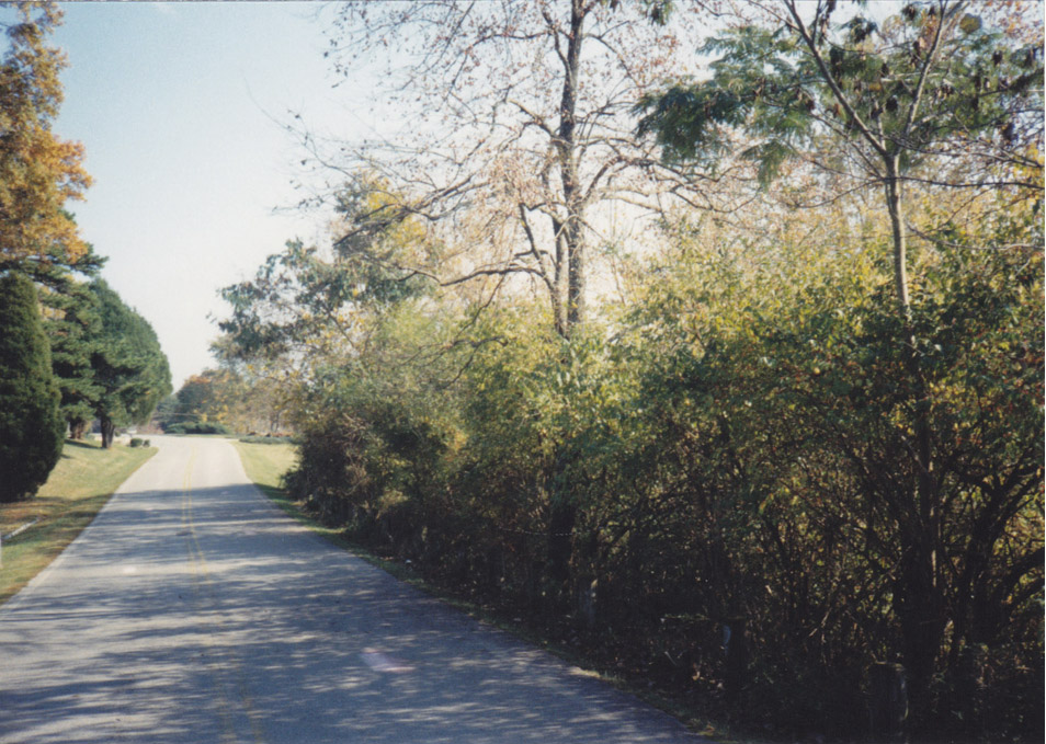
By April 30, 1948, Roehl Construction Co., Inc., 625 Atchley St., Knoxville, had cleared, excavated, engineered and laid pipe for Timberlake Drive at a cost of $8085.20. Their estimate to complete this work and rocking the road was $6314.00. They estimated the length of the road to be 6200 feet [Correspondence date May 1948 between E.K. Stokes and D.W. Barber in files of TCC]. According to Charles Dempster, when he moved to Timberlake Road in 1961 with his parents and siblings, the road was still gravel; he indicated it was white gravel that did not melt the snow as fast as the blacktop, so made for longer sledding in the winter.
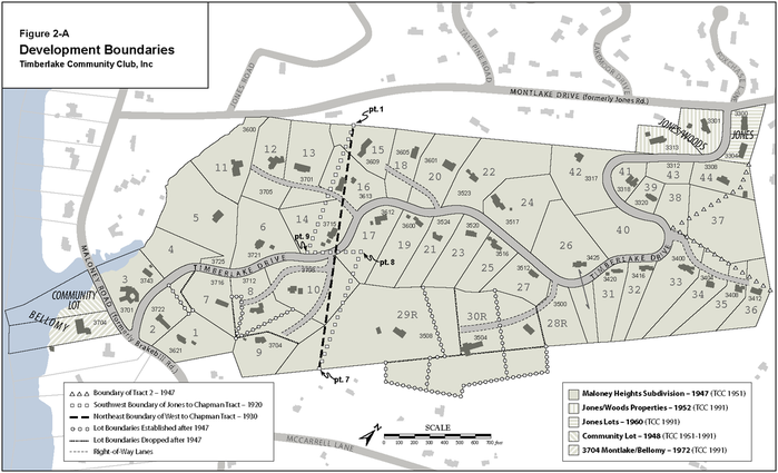
Subsequent to the sale of the property to Maloney Heights Inc., Sue J. Chapman acquired the mineral rights, rent and other income, and access to, Tract 2. She conveyed all of these to Maloney Heights Inc. in 1948 [WD 788, p. 194]. The mineral rights for Tract 2 were probably for marble based on the mention in previous deeds of a lease to Tennessee Producers Marble Company dated January 2, 1893 [WD 432, p. 118]. This tract comprised what is now the north part of lots 35 and 36, most of lot 37, and the east part of lots 38 and 44 (see line indicated by triangles on Figure 2-A).

The deed conveying the land for Maloney Heights Subdivision from Sue J. Chapman to Maloney Heights Inc. indicates that Tract 1 was purchased by D.C. Chapman and Sue J. Chapman in 1920 from R.G. Jones and his wife, S.J. Jones, and W.H. Jones and his wife, Linna Jones. The Chapmans had purchased this tract for $4085 in 1920. The Jones did “forever reserve for themselves and their heirs and assigns the right of way for a pipe line to the spring located upon the land” described in the deed [WD 373, p. 63]. I have found no indication that this reservation has ever been conveyed from the Jones to the Chapmans, Maloney Heights Inc. or any landowner in the subdivision. There are a number of springs on Tract 1, but the one mentioned in this reservation may be on lot 24. This spring is near land on Montlake Drive which was owned at one time by W.H. Jones. Also, it is the source or one of the sources of the creek that is on the northwest side of Montlake Drive from about Tall Pine Lane to where it crosses under Montlake Drive between 3700 Montlake Drive and 3725 Maloney Road. The meander of this creek from Montlake Drive to Maloney Road was used as the west boundary of Maloney Heights Subdivision.
The 1920 deed conveying the land from the Jones to the Chapmans indicates that Tract 1 is 81.7 acres. Since this is considerably less than the 109 acres indicated in the deed conveying the two tracts to Maloney Heights Inc., I checked the area using the bearings and distances given in the 1920 deed and conventional surveying procedures for calculating area. My calculations resulted in an area of 82.7 acres, acceptably close to that in the deed. The boundaries from the 1920 deed agree with those of Tract 1 in the 1947 deed except at the southwest end of Tract 1, where they cut across lots 29, 10, 17, 14, 13, 16, and 15 (see lines indicate with squares on Figure 2-A), resulting in about 27 acres unaccounted for.
The most likely place to trace ownership of the portion of Tract 1 described in the 1947 deed, but not in the 1920 deed, was deeds of adjacent land, specifically that land on Maloney Road that shared the meander of the creek with Tract 1. A search of deeds led to a deed from Frank L. West, Clerk and Master of Chancery Court at Knoxville, to D. C. Chapman and Sue Johnston Chapman. This land sale was in settlement of a lawsuit between two parties other than the Chapmans [WD 437, p. 235, dated 10 October 1930]. This deed was for a tract that followed the meander of the Tennessee River. The sides that commence at each end of the meander have the same bearings as the two long sides of Tract 1. Each of these sides end at a point having the same description as in the 1920 deed between the Jones and the Chapmans for what is Tract 1 (points 1 and 7 on Figure 2-A) and the distance between the end points agrees with the distance between the end points across Tract 1 (the dashed line on Figure 1‑A). The only discrepancy between the 1920 deed and the 1930 deed is that the single straight line on the 1930 deed has the same bearing as the line from point 7 to point 8 and the line from point 9 to point 1 (again see Figure 2-A for this discrepancy).
The portion of the tract in the 1920 deed not conveyed to Maloney Heights Inc. became the three lots on the north side of Maloney Road between Montlake Drive and the inlet of Fort Loudoun Lake (3725, 3717 and 3711), five lots on the south side of Maloney Road to the west of the inlet (3732, 3728, 3714, 3710 and one lot that is undeveloped and thus lacks a street number), four lots and a small portion of a fifth lot on the south side of Maloney Road east of the inlet (3704, 3700, 3628, part of 3620 and one unnumbered lot), and the lot at 3613 on the north side of Maloney Road east of the Maloney Heights Inc. land. The house at 3704, on the south side of Maloney Road, is in the Timberlake community as is the adjacent lot that formerly belonged to the Timberlake Community Club Inc. (see below).
The 1947 deed that conveyed the land from Sue J. Chapman to Maloney Heights Inc. does not include a reference to a deed by which the Chapmans acquired that is called Tract 2. The 1947 deed does include reference to an earlier deed in the description of the incumbrances. Using the direct index in the Knox County Registrar of Deeds’ office, I found the deeds for the land acquired by D.C. Chapman that probably included Tract 2 [WD 354, p. 458 and WD 432, p. 118]. I could not be certain of this because the boundary description used in the deeds conveying this land over the years uses the survey that was done in 1873 [maybe earlier] and that survey does not have complete descriptions of all the boundaries. Tract 2 appeared to be part of two tracts of about 150 acres that Alexander R. McBath, Executor of Alexander McBath, sold to James H. Cottrell on February 1, 1873 for $755 or $775 [Book P, Vol. 3, p. 446, Knox County Archives]. Alexander McBath acquired this land, known as the Baines Farm, on 24 October 1845 from George Baines [Book K, p. 141]. Martha I. Cottrell, widow of James H. Cottrell, sold the two tracts to S.H. Duncan on 28 May 1913 for $2000 [WD 270, p. 219]. S.H. Duncan and his wife, Blance B. Duncan, sold the land to A.A. Schmid on 30 May 1913 with no price given [WD 270, p. 217]. A.A. Schmid used the land to borrow $7500 from H.A. Harth, defaulted on the loan, and then bought the tract back at auction at the front door of the courthouse for $4750 on 26 June 1915 from LeRoy D. Harth, Trustee[iii] [WD 272, p. 181]. On 12 November 1915, A.A. Schmid sold this land to John E. Shea for $7400 [WD 290, p. 6]; A.A. Schmid retained the lease to the Tennessee Producers Marble Co.; this deed also mentions that this property had been conveyed to M.E. Thorn from A.A. Schmid, but does not indicate a citation of that deed. On 28 February 1919, Charles H. Harvey bought the land from John F. Shea and his wife Harriet M. Shea, for assumption of a note for $2133.34 to H.A. Harth and other considerations; the Sheas retained the lease to the Tennessee Producers Marble Co. [WD 312, p. 114]. On 1 May 1919, Charles H. Harvey sold a half interest in this land to Davis [sic] C. Chapman [WD 354, p. 458]. The second half interest in this land was conveyed from Charles H. Harvey to David C. Chapman on 1 September 1922 [WD 432, p. 118]. Between the conveyance of the two halves of interest in this land from Harvey to Chapman, Harvey and the Chapmans, and William and Andrew Maxey, owners of adjacent land, exchanged three small tracts of land to straighten the boundary between the Harvey and Chapman land and the Maxey land [WD 341, p. 455 and WD 559, p. 550]. This land exchange resulted in the only change in the boundary survey for these two tracts since 1873, maybe earlier.
After searching for the deeds described above, I reviewed the Timberlake Community Club, Inc. files from the development of the Timberlake community. These files include a copy of the Option to Purchase between the directors of Maloney Heights Inc., and Sue J. Chapman. This agreement states that Tract 2 in the Maloney Heights subdivision is a triangular part of Tract 1 in 1919 and 1922 deeds cited above from C.H. Harvey to D.C. Chapman.
Osborne H. Graves, a landscape architect with TVA, served as site planner and Addison Hook was the engineer for the Maloney Heights subdivision. If I remember correctly, George Barber told me that Graves walked over the tract and located house sites with views of the lake or the mountains or both. The lots were then laid out around these prime house sites and then the remaining lots laid out. The surveying of the lots was done by Addison Hook with the help of George Barber and Dean Barber, all long time residents of Timberlake.

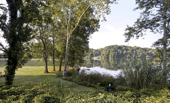
Figure 2-B: community property (former) on Maloney Road.
In 1948, a lot between Maloney Road and Fort Loudoun Lake was purchased from Sue J. Chapman for $1000 and held as community property [WD 788, p. 532] by Maloney Heights Inc. The Timberlake Community Club was incorporated in 1951 by Mrs. J.H. Taylor, D.W. Barber, Wylie Bowmaster, Fred C. Smith and A.H. Nielson, all residents of the Timberlake community. In September 1951, ownership of the community lot was transferred from Maloney Heights Inc. to the Timberlake Community Club, Inc. [WD 872, p. 439].
While the Timberlake Community Club, Inc. owned the lot between Maloney Road and Fort Loudon Lake, membership was made up only of people living and/or owning lots in the Maloney Heights Subdivision. With the disposition of the community lot, the other families living on Timberlake Drive were invited to become part of the organization.
While the Timberlake Community Club, Inc. owned the lot between Maloney Road and Fort Loudon Lake, membership was made up only of people living and/or owning lots in the Maloney Heights Subdivision. With the disposition of the community lot, the other families living on Timberlake Drive were invited to become part of the organization.
The board of directors of Maloney Heights Inc. did much work in creating and establishing the Maloney Heights subdivision. They had to establish the corporation, locate and secure the land, finance the land purchase with their own funds and through loans, get approval for the subdivision from Knox County, sell the lots not selected by the directors and pay taxes related to owning the land and to the corporation. To transform the undeveloped, mostly wooded tract into a subdivision, they needed to divide the tract into lots, have a road and lanes build for access to the lots, and arrange for water, electrical, and postal service. Some of the directors served on a planning committee that reviewed the plans for houses proposed in the subdivision. The planning committee ceased to exist on June 1, 1958. Copies of correspondence and meeting minutes detailing many of these activities are in the Timberlake Community Club, Inc. files.
A few changes to the original boundaries have occurred over the past 60 years. The descriptions of these changes are based on a comparison of the original plat with the lots as shown on the Knox County GIS [www.kgis.org]. They are shown on Figure 2-A with circles on the new boundaries and dashed lines on the boundaries that were replaced.
In 1953, lots 29, 30 and 28 were resubdivided: the southwest side of lot 28 was moved southwest about 240 feet and the southwest side of lot 30 was moved about 220 feet southwest [Map Book 19, p. 165, June 27, 1953]. In 1965, the owners of lots 29R[iv] and 30R purchased land adjacent to their lots. This resulted in 1.09 acres being added to lot 29R [WD1290, p. 73] and 4.00 acres being added to lot 30R [WD 1293, p. 70]. In 1969, the owners of lots 28R and 30R purchased land adjacent to their lots, resulting in 1.02 acres added to lot 28R [WD 1409, p. 262], and 1.12 acres being added to lot 30R [WD 1409, p. 264]. In 1977, 2.63 acres of the 4.00 acres added to lot 30R, was sold [WD 1624, p.667], retaining 1.37 acres adjacent to lot 30R.
Other changes involved lot 7. In 1998, the portion of lot 1 that connected it with Timberlake Drive was conveyed to lot 7. Also, about two-thirds of the distance up of the northeast side from the extreme east corner of lot 7, the property line was moved about 50 feet northeast into lot 8 while maintaining the location of that line at its southeast end.
Another change was to extend and rotate to the west, the west side of lot 9 across lot 8 until it intersected with the north side of lot 8.
[i] As of August 2009
[ii] D.C. Chapman was Colonel David C. Chapman, “The Father of the Great Smoky Mountains National Park,” who died July 26, 1944.
[iii] It is no longer legal to default on a loan and then for the person who defaulted to buy the property at auction.
[iv] R indicates that the lot has been resubdivided.


