Section 1: Timberlake Area History, 1783-1948
By Dan Reiff, October 2009

The story of the early settlement of the Timberlake area of South Knox County mirrors that of the rest of East Tennessee – blossoming after 1783, when the North Carolina legislature passed a law granting land warrants as payment to Revolutionary War soldiers. Entitled “An act for opening the land office for the redemption of specie and other certificates, and discharging the arrears due the army,” this legislation has been credited for initiating land ownership and encouraging settlement of the “Cumberland Country” and East Tennessee.
Appendix A of this report lists owners of each lot in the Timberlake neighborhood since 1948. Section 2, The Development of the Timberlake Community Property, provides a documented account of ownership of the Maloney Heights/Timberlake area property dating back to a circa 1873 survey. Prior legal records of ownership aren’t available, but the history of settlement in the area around the neighborhood began about one hundred years earlier.
In celebration of the U.S. Bicentennial, area residents compiled a small publication called A Historical Sketch of Alcoa Highway – Maryville Pike Section of Knox County, 1776-1976. The booklet contains information about early pioneers and families who settled in the Montlake/Maloney area of Knox County. The Historical Sketch is an undocumented assimilation of personal accounts, and there are a few impossible timeline discrepancies in some biographical material; however, it provides a wonderful overview of the area’s key pioneer families as conveyed by their descendents. This booklet is available for viewing online as a pdf file (or by clicking on the cover at the upper right). A text version of the document (with a few minor typos corrected) is included in Appendix G.
Another book written by a local resident which describes events of historical significance prior to the 20th Century is William Rule’s Standard History of Knoxville, TN, Lewis Publishing Company, Chicago, 1900. William Rule (1839-1928) was a former postmaster and mayor of Knoxville and editor of the Knoxville Journal. According to the Historical Sketch, he lived on Jones Road (Montlake) and was the son of Frederick Rule and Sarah Elizabeth (Brakebill) Rule. William Rule’s text is available online in its entirety at Google Books (http://books.google.com).
Much of the information that follows is summarized from the Historical Sketch and Rule’s Standard History of Knoxville. Both are certainly worth reading in their entirety.
Much of the information that follows is summarized from the Historical Sketch and Rule’s Standard History of Knoxville. Both are certainly worth reading in their entirety.
In the 1830’s James W. Maloney, a descendent of Capt. Henry Conway, came from Greene County, TN, and built a log cabin in the area of what is now 3717 Maloney Rd., along the creek that forms the southwest border of the Maloney Heights tract below 3600 Montlake and 3725 Timberlake. He and his wife, Minerva E. King, are buried in the Wells Cemetery. Their son, George L. Maloney, fought for the Union Army during the Civil war and returned to Knoxville after the war. George married Sonora L. Dodson in 1868 and raised one daughter and four sons, one of whom was Frank Maloney (1879-1952). Maloney Road, formerly Brakebill Road, was named after the Maloney family, as was the Maloney Heights investment group that developed the subdivision by the same name. Three graves moved to Mt. Olive Cemetery from the subdivision land were Maloney family relations.
The Maloney family’s Knox County roots were along old Brakebill Road, but the family’s contributions extended far beyond the area. Frank Maloney’s life accomplishments, through both military and civilian service, were of particular significance. He served as Adjutant General of the Tennessee National Guard from 1911 to 1915 and put his engineering degree from the University of Tennessee to use in the planning of Fort Benning, Georgia. Later, in his civilian career, Frank Maloney directed the Knox County highway department, planning commission and housing authority. He is most widely remembered, though, for his role in the founding of the Great Smoky Mountain National Park: he determined the accepted park boundaries, established the route of the Foothills Parkway, and became president of the Smoky Mountains Conservation Association following the death of Col. David C. Chapman (1877-1944), who led the campaign for the park in the early days.
Coincidentally, 23 years prior to Frank Maloney’s succession of David C. Chapman on the Smoky Mountain Conservation Association, Chapman had purchased the former James Maloney property from Roy Jones, along with all the land on “Chapman Ridge” that would later become the Timberlake neighborhood. Chapman and his wife, Dorothy, built a splendid home called “Annondale” near the location of the original Maloney cabin. The house was destroyed in a fire in the late 1930’s, and, according to the Historical Sketch, they moved to Topside Road to live with a sister. Timberlake resident, Lonnie Brown, claims the Chapmans actually moved back for a time to a house they owned at 4622 Wye Way Lane, displacing his family who had been renting it in the late 1930s. Chapman’s legacy of helping establish the Great Smoky Mountain National Park is well documented, with the fourth highest peak in the park named after him, as well as the highway leading from Knoxville to the park.
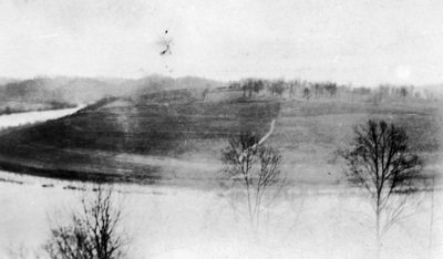
Figure 1-A: View of Peter Blow’s
Farm from the Lyons
Bend, circa 1920
In the early 1900s, access to the area was available via Blow’s Ferry (at the far north end of the bend in the river across from Sequoia Hills) or from Woodson Drive or Maryville Pike from the east. There was a bridge crossing the river connecting the original Cherokee Farm to the main agriculture campus at the University of Tennessee. The original “Buck” Karnes Bridge across the Tennessee River, completed in 1935, helped open up the area for residential development along US Highway 129. One of the first newcomers was Judge Thomas Goodman, who bought part of Colonel Harvey’s estate in 1936 and built a house at 3824 Maloney Road. The area remained mostly rural and sparsely populated by a handful of farming families until after WWII.
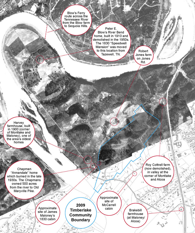
An aerial photo from 1935 (figure 1-B below) shows many of the property sites described in the Historical Sketch prior to the residential boom in the 1950 and 1960s:
An aerial photo from 1935 (figure 1-B below) shows many of the property sites described in the Historical Sketch prior to the residential boom in the 1950 and 1960s:
- Peter E. Blow’s River Bend home, built in 1910, and demolished in the 1950s. The 1830 “Speedwell Mansion” was moved to this location from Tazewell, TN.
- Robert Jones farm on Jones Road (corner of Lakemoor and Montlake)
- Roy Cottrell farm (now demolished), in the valley at the corner of Montlake and Alcoa
- The Harvey farmhouse (corner of Montlake and Maloney), one of the oldest original homes in the area
- Site of James Maloney’s 1830 cabin
- McCarrell cabin and farm, settled in the 1700s. A spring-fed creek along the south side of Timberlake road was still identified as “McCarrell Spring” on a 1978 TVA map.
- Brakebill Farmhouse (Maloney/Alcoa) James H. Brakebill (1843-1931) was a descendent of Peter Brakebill, a Union Soldier from N.C.
- “Annondale” site, D.C. and Dorothy Chapman’s showplace home on Maloney Rd. which burned in the late 1930s. They owned 500 acres from the river to Old Maryville Pike.
- Wells Cemetery on Manor Drive
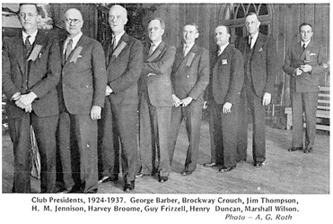
Figure 1-C: Smoky Mountain Hiking
Club Presidents, 1924-
1937.
The Smoky Mountains Hiking Club and the Tennessee Valley Authority brought together the group of investors who developed the Maloney Heights subdivision. When Dorothy Chapman sold the section of Chapman’s Ridge in 1948, she passed the land to people who shared her late husband’s fondness of the mountains. Brockway Crouch, one of the investors, had been an early president of the Smoky Mountains Hiking Club, and several members of the Barber family had been past members. TVA engineer, Addison Hook, who served as site engineer for the neighborhood, met his wife, Nancy, through the hiking club. They built their home at 3523 Timberlake with a view of Gregory Bald. Wylie and Roma Bowmaster, instrumental in drafting the Timberlake community association bylaws and charter, also met through the hiking club. The Bowmasters moved from the TVA town of Norris when it was auctioned by the federal government, and they built their home – one of the first completed in the neighborhood – at 3601 Timberlake in 1948, moving in with their children before the interior walls were completed.
The Smoky Mountains formed the early backdrop of the Timberlake neighborhood history – motivating Chapman and Maloney to help create the National Park, drawing together the Maloney Heights Inc. investors, and influencing the design of the subdivision. As a constant neighbor, the Smoky Mountains would continue to beckon and inspire those living on Timberlake. Some of those stories are told in later sections of this report and in Part II.
The Smoky Mountains formed the early backdrop of the Timberlake neighborhood history – motivating Chapman and Maloney to help create the National Park, drawing together the Maloney Heights Inc. investors, and influencing the design of the subdivision. As a constant neighbor, the Smoky Mountains would continue to beckon and inspire those living on Timberlake. Some of those stories are told in later sections of this report and in Part II.
